


Sala 20200224

cmike39
User
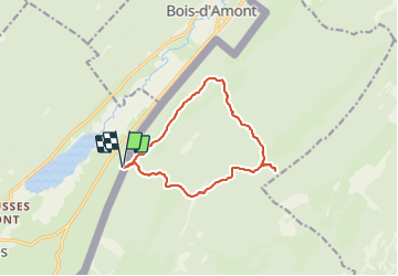

Length
11.9 km

Max alt
1527 m

Uphill gradient
473 m
Km-Effort
18.2 km

Min alt
1122 m

Downhill gradient
468 m
Boucle
Yes
Creation date :
2022-02-24 08:56:16.283
Updated on :
2022-02-24 14:38:05.798
5h40
Difficulty : Difficult

FREE GPS app for hiking
 SityTrail
IGN / Geographical institutes
SityTrail Plus
The world is yours!
About
Trail Walking of 11.9 km to be discovered at Bourgogne-Franche-Comté, Jura, Les Rousses. This trail is proposed by cmike39.
Positioning
Country:
France
Region :
Bourgogne-Franche-Comté
Department/Province :
Jura
Municipality :
Les Rousses
Location:
Unknown
Start:(Dec)
Start:(UTM)
278191 ; 5154066 (32T) N.
Comments